 |
||||
|
|
||||
|---|---|---|---|---|
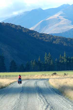
7th March 2006 - Mount Cook to Omarama - 76 km As we left cloudy Mt Cook behind us, the North West wind pushed us to speed up to 45 km/hr without even pedaling. It felt like touring on mopeds rather than cycling. Unfortunately this was a short-lived pleasure: after each bend in the road we had to struggle to reach 10 km/hr. We stopped at Omarama where the road took a sharp turn West, or in other words where the wind was blowing straight against us. We rested our tired legs and untangled our hair there (the latest concerns Isa only).
|
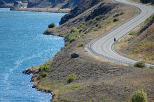
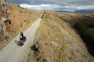
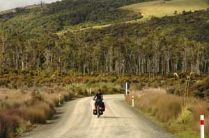
A cool day on Lindis pass, beautiful landscape - but we get a sense that autumn is on it's way again |
|||
|
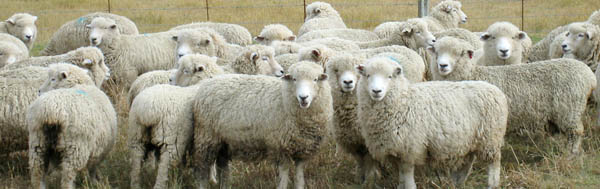
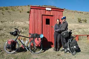
Apart from the scenery the highlight of the day was talking to an irrigation engineer who was installing a 1.2km long self driven irrigation system. "I never thought I'd see irrigation here" he said. The reason is the spread of dairy farming - the area only receives 50 cm of rain a year but the profits are attractive enough to install enormous and wasteful irrigation systems - spraying water into the 80 km/hr winds under the midday sun. Meanwhile the rest of Canterbury is under water restrictions and Canterbury domestic wells are going dry. (left top) The bone dry sheeplands of central Otago, overgrazed and underwatered. Much of the land is being converted to dairy which using even more water |
|||
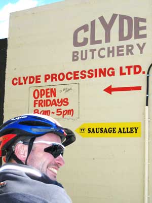
Terry off to investigate "Sausage Alley"
|
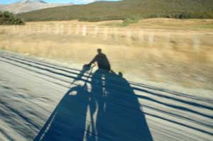
7th March 2006 - Omarama to Cromwell - 115km We started cycling early following the locals' advice: the wind does not blow in the morning. It was true and we made it up to Lindis pass with a minimum amount a struggling and cursing against the wind. It was very cold up there: the thermometer hardly reached 8dC and it was nearly midday. Autumn is definitely on its way. The rest of the road was much nicer than we had cycled since leaving Christchurch. We finally left behind all the tour buses that shipped jet-lagged tourists between Christchurch and Mt Cook and it was downhill all the way to Tarras. The landscape, though extremely dry, was beautiful. We saw water again when following the Dunstan lake (created in 1993 only for hydroelectricity production) to Cromwell. Unfortunately the wind had by then decided to blow from the South, making the last 30 km unnecessarily painful. As for Cromwell, it is the "fruit bowl of the South", as testified by a giant pear, peach and apple in the town centre. It somehow looks out of place in such dry surroundings. |
|||
Sometimes it felt like we were back in China - people staring at us all the time
|
||||
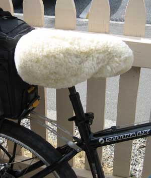
(above) The sleepy Clyde township - now famous as the starting point for the Otago central rail trail (left) The New Zealand version of the comfort saddle - pure sheepskin |
|
|||
An old wooden bridge on the rail trail
|
Descent to Omakau
|
|||
No traffic, safe cycling, great views
|
The wonderfully scenic Poolburn gorge
|
|||
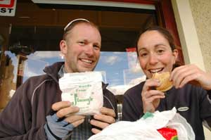
Jimmy's Pies - get a thumbs up from the cyclists outside the Gilchrist store in Oturehua
|
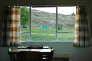
The campsite kitchen in Omakau, last decorated in 1971
|
|||
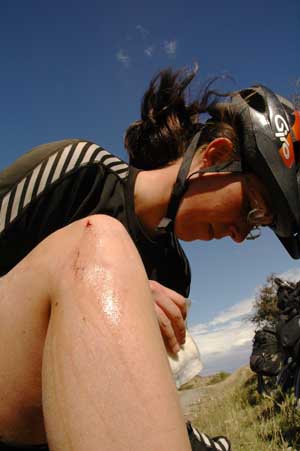
Cycle tracks are not so safe after all, Isa was blown across the track, skidded and was plonked onto the rough, stony surface. Minor cuts and lacerations and a chance to use the first aid kit
|
One of the shelters on the rail trail
Tea, coffee and cake - an essential refuelling stop on the rail trail |
|||
A normal road obstruction |
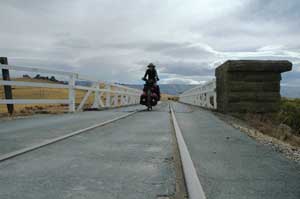
Road and rail sharing the same bridge - good timing is essential
|
|||
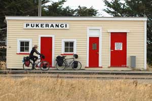
The end of the rail trail and a 20 km ride, mostly on gravel to a remote railway station and the train to Dunedin
|
9th to 11th March 2006 - The Otago Central Rail trail - 150 km From Cromwell, we reached the very pretty stone village of Clyde where the Central Rail trail starts. It is an old train line which has been converted to a gravel track for recreational purpose. It crosses some bleak and colourful landscape and makes for a very pleasant few days of riding, far from the cars and without any strenuous slopes. As for the wind, you would know by now that there is no way of predicting when and where from it blows. It was hellish on our second day cycling, but thankfully in our backs as we were heading South East. There were a few people coming the other way and the look on their face told it all ("it" being the pain and their cursing the wind). Isa got knocked off her bike at the highest point of the track by the wind and lost a bit of skin and pride on the gravel! The track crosses the coldest and hottest town of NZ, Oturehua, with temperatures ranging from -10dC to 40dC during the year. We also passed through the 45 degree South latitude twice in the same day. It might not be something worth shouting about, but we have been struggling to find some "facts of the week" lately, so here you go! Middlemarch marks the end of the rail trail and we chose to take the scenic train from the tiny Pukerangi station to Dunedin, which follows the Taieri gorges. Before hitting the tourist trail again, we cycled 20 km through a weird landscape of schist rocks, all strangely eroded by the wind into tors. It was our favourite section of these few days in the central Otago plain. |
|||
|
 |
|||
|
The remote Pukerangi station is the terminus for the train to Dunedin. A fantastic 2 hour trip that was great - and a real treat after so much cycling. The carriages are completely wooden and varnished. There are outside sections so that you can climb on the roof and fight off the Indians (if necessary) |
|||
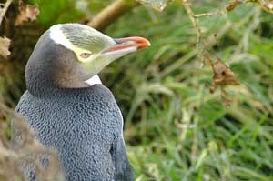
(left) The Otago peninsula is a excellent place to see some rare and fascinating wildlife see our flora and fauna section for more details |
12th and 13th March 2006 - Wildlife encounter and sheltering from the wind in Dunedin We offered ourselves the luxury of a guided tour to see the wildlife of the Otago peninsula. Within a few hours, we saw some mighty Albatross, playful fur-seals, penguins and lazy sea-lions. It was a real feast for the eyes and Terry is struggling to select the best of the many shots he took. There are a few of them in our flora and fauna section. Dunedin is otherwise a pleasant city, but not necessarily for the cyclists. It is surrounded by hills and the planners made no rooms for bends. Baldwin street has made it in the Guinness book of records for being the steepest street in the world with a steepness of 1 in 1.266. And no, we have not tried to cycle it!
|
|||
|
14th March 2006 - Dunedin to Waihola - 54km We hit the road, or rather the road hit us. We had to waddle our way up a massive 14% hill before leaving Dunedin behind us, all panting and sweating. The rest of the road was easier and lovely - it was the beginning of the Southern scenic road, which follows the whole of the South coast. The actual route follows the bigger roads but there are plenty of alternatives and diversions (most of them on gravel roads). We decided to carry on 12 km from Taieri Mouth to Waihola campsite, the gentle, flat dune landscape gave way to an endless, vicious hill, in a typical kiwi style, i.e, a succession of short and snappy uphills. In all 300m straight from sea level on gravel! We were well and truly knackered when reaching Waihola. |
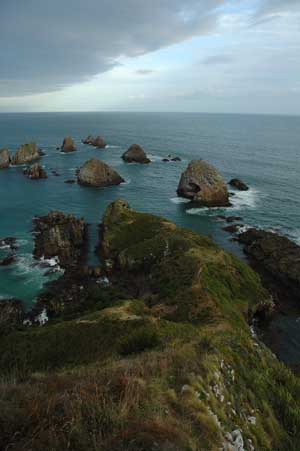
The nuggets of Nugget Point poking out into the Southern Ocean
|
|||
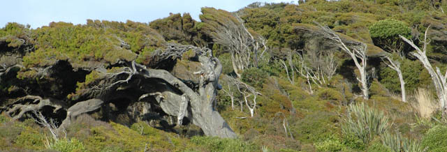
The weather beaten trees atop Nugget Point, we chose to camp a little lower down
|
||||
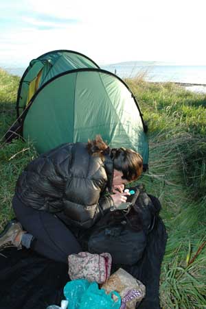
Camping and contact lenses - not the best combination - especially when your wild camping is next to the salty sea and sandy beaches
|
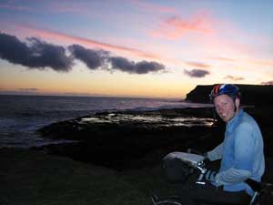
15th March 2006 - Waihola to Kaka Point- 81km We did not enjoy the scenic road up to Balclutha. It is very busy, too wide, too fast and has a succession of thigh sapping inclines. It soon became more pleasant and less busy on the way to Kaka point (this name always gets a smile out of Isa as its French meaning is "poo point". Easily amused!). From Kaka point we followed the gravel road to Nugget point, the road is really quiet and it hugs the coastline. At Nugget point, we took in our first view of the Southern Ocean and spied a few seals colonies down below us on rocky beaches.
|
|||
16th March 2006 - Kaka point to Curio Bay - 91km This was our best day through the Catlins. We followed a network of quiet gravel roads close to the coast. We cycled between the sea and the thick native bush (full of singing birds) and there were many countless breathtaking, brake inducing views onto the ocean, beaches and woodlands. It made the hilly terrain a bit less painful. The route is a good days cycle as it climbs 1200m through the lumpy Catlins coast. Although the roads are gravel they are in good condition and the reduced speed of the motorised road users is a big bonus - but the dust isn't!
|
Gravel roads and some remains of the old beech temperate rainforest |
|||
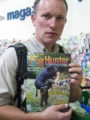
(above) A lovely sunset on the Catlins coast - looking towards Antarctica (left) With pigs as dangerous as this one it is no surprise that Pig Hunting is so popular - just watch your back |
 |
|||
The Catlins coast has some amazing beaches - this one at Tautuku Bay
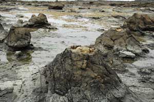
Left over trees stumps at Curio Bay - these ones are 180 million years old (only available at low tide)
|
17th March 2006 - Curio Bay to Invercargill - 94km This was our easy day and we investigated Curio bay all morning. We spotted two yellow-eyed penguins walking gingerly back to their nest. They simply crossed the fossilised trees (or should we say stumps?) on the beach for which Curio bay is famous. It was at the time invaded by two buses of tourists. Not the most discreet way to go back home for a quiet rest! There was also a bit of dolphins spotting to do, but they have decided to spend the day out of sea. We carried on to Waipapa point where a colony of young male sealions gave us a good display of fighting techniques - a lot of growling and "You Looking at me" type behaviour (it was a lovely reminder of the drunks found in most English pubs come closing time at 11 o'clock). We quickly realised that the wind was magically blowing from the East. Looking at the bent trees all around us, clearly leaning the other way round, we decided to take advantage of our good luck and to cycle our legs off to Invercargill (we took the decision at 6 pm and had 47 km to go!). So much for an easy day! |
|||
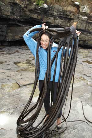
Bull kelp clinging to the rocks - it will not budge- it really is tough stuff similar to leather
Two young sealions at Waipapa point engaged in a shouting match - the winner received a harem of 30 young female sealions |
Isa had her hair cut to manageable proportions before we left England - perhaps it may be time for another visit to the hairdresser, but Isa insists a change of conditioner will do the job. |
|||
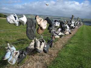
A Catlins shoe fence (?!?) 18th March 2006 - Invercargill We were so pleased to have made it to Invercargill: the wind was now blowing from the West. Invercargill is rather pleasant, but the only common thing it shares with Scotland is the under-glass, no access off-license. All drinks are away from the customer reach. It is more akin to a visit to the chemists - "Something for the weekend sir?", "Would you like Strong Lager or Numb your Mouth and anaesthetise-your-head lager? The supermarkets in Invercargill are not allowed to sell alcohol, Terry wandered around a supermarket three times before an assistant broke the bad news.
|
The trees were blown the opposite way to our direction of travel - but the wind was with us - we made the most of it and carried on into the dusk and finished at Invercargill
|
|||
15,000 kms on the road to Manapouri with Alaistair, the last 1000 kms has worn Isa's legs down to little stumps
|
19th March 2006 - Invercargill to Clifden - 80km We left the Southern scenic route and carried on inland, mainly to dodge the South Westerly wind. A pleasant day through the hills with plenty of alternative roads (a real luxury in New Zealand). We ended up at Clifden suspension bridge over the river Waiau, an informal, free campsite with water, toilets, a lovely setting and all provided by the local scout troop. Bob-a-job has come a long way since Terry was a nipper. |
|||
20th March 2006 - Clifden to Manapouri - 70km We met Alaister, a scottish cyclotourist, whilst still at the Suspension bridge. So Isa had two wind-shelters to help her cycle through the Northerly wind (yes, it changed again!). Though we were now in Fjordland, the road was surprisingly flat but the mountains were starting to shape up in front of us. We reached Manapouri still not quite sure what the next few days would hold for us. |
Isa refusing to slow down for that glamour shot
|
|||
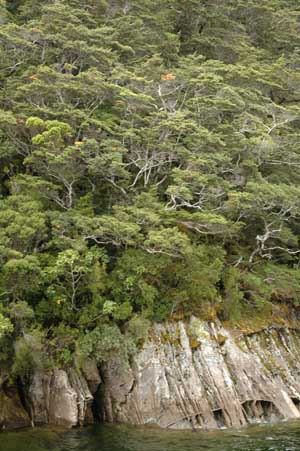
The typical impenetrable ancient beech rainforest on the West Coast of New Zealand - growing on solid granite with a layer of moss - remarkable. When a tree gives way the result is a tree avalanche, leaving an ugly scar down the mountain side for 100's of metres |
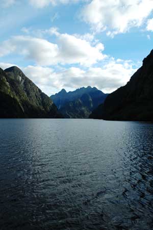
21st to 24th March 2006 - Manapouri to Te Anau - 23 km and a bit of pure tourist touring We decided to break the kitty and visit two Fjords: Milford and Doubtful sounds. Doubtful was quiet and beautiful while Milford sound was more impressive with its sheer cliffs that drop straight into the sea. The road to Milford Sound deserves a special mention for being the most beautiful we have seen so far. If you manage not to be annoyed by the hordes of buses going back and fro, it is simply stunning. We have done it by bus and regretted it - it deserves to be cycled at a leisurely pace. We have also done a tentative day walking up the Kepler track to Luxmore hut, but ended up in the middle of a big cloud and backtracked. It is part of the great walk network that cover NZ and the track is amazingly wide, smooth and easy - even though it climbs over 1000m. Expect stairs, decking boards and plenty of warning signs when the path is not smooth enough or slightly muddy! (Since the walk we have discovered that the DOC (Department of Conservation) classify travel on foot in three ways:
|
|||
Back to work: the inside of the Manapouri West Arm Power Station. Producing about 20% of New Zealand's power about 700MW (in comparison the three gorges dam in China produces 25 times more power at 18GW, or enough to power New Zealand 5 time over!)
|
Doubtful Sound from Wilmots Pass |
|||
View up Doubtful Sound to the opening to the Tasman Sea
|
Doubtful Sound Dolphins - they jumped and frolicked and left everybody completely enthralled
|
|||
Bright Sunshine on Milford Sound - but the waterfall still keep on tumbling down the vertical cliff faces
|
Terry below Mitre Peak on Milford Sound
|
|||
Deep Cove arm of Doubtful Sound
|
After 15,000 kms in the saddle this sign was particularly accurate
|
|||
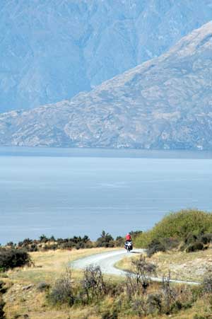
25-26th March 2006 - Te Anau to Queenstown via the Mavora Lakes - 137km After the first 30 km of tarmac road, we turned left onto 100 km of gravel track. We spent the night camping by the Mavora Lakes. The two lakes are set in the midst of a native beech forest and and surrounded by mountains. It was one of the many locations for some scenes of Lord of the Rings. Still, no sign of hobbit here: the deal was to restore everything to its original condition after the shooting. The road from the lakes up to Walter peak was pretty much deserted of cars and tourists. And the landscape turned out to be absolutely awesome. It was similar to that on the Molesworth track and when it is so beautiful, it makes you feel like cycling forever (well, let's say for quite a long time, until you get bored of all the stunning landscape). At Walter peak, we hit the tourist trail again and boarded on an old streamer boat who took us across lake Wakatipu to Queenstown.
|
The quiet gravel road to Lake Mavora
|
|||
Daylight-saving finished in Mid-March in New Zealand meaning the nights are closing in quickly - inevitably leading to us cycling into the long shadows of dusk |
North Lake Mavora |
|||
The road from Lake Mavora to Walter Peak Station
|
At Queenstown, a bad discovery was awaiting us: Terry's Rohloff hub flange was split where a spoke had pulled through! With a repair needed in Germany this is a major problem and we don't know what is going to become of our cycling trip for the time being... ... How is this for an obvious cliff-hanger?
Luckily it hadn't rained for a week so the river crossings were easy |
|||
Isa taking the river crossings very seriously - no time for a "Yahoooo!" here
|
Skirting around the edge of Lake Wakatipu on the way to Walter Peak Station and the old Steam Ship to Queenstown
|
|||
Gravel roads and corrugations caused by speeding 4x4's can put a great deal of strain of fully laden touring bike |
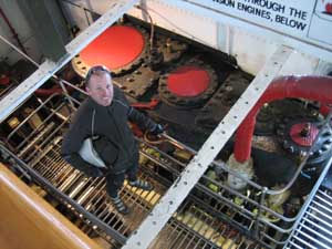
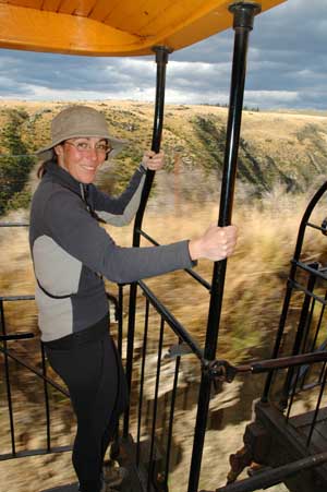
Terry inspecting the steam engines of the TSS Earnslaw - it burns one ton of coal an hour
|
|||
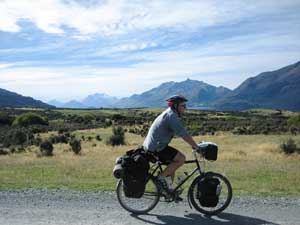
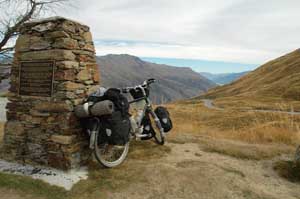
27th March 2006 - Queenstown To Wanaka via the Crown Range - 81km We did not dwell in Queenstown. Many cyclotourers warned us about the inflated prices and the enormous range of adrenaline-inducing activities that suck money out of your wallet. We quickly found out that staying in a campsite here was nearly as expensive as a double room in a backpacker in some less expensive towns ($35) and got scared away.
|
Isa puffing and panting up one of the 16% climbs to the Crown saddle
|
|||
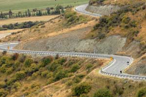
(above) The Crown Saddle is the highest paved road in New Zealand (Right) What goes up must come down - 40 km downhill - cycling heaven |
|
|||
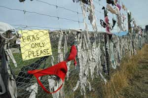
An Otago bra fence (?!?)
|
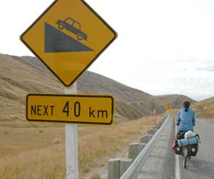
We crossed Arrowtown, a very pretty though a bit too much done up, old village from the gold mining era. It also had a derelict "China town" who used to be home to Chinese miners. An interesting set of boards made us realised that the problem between NZ and Chinese migrants are nearly 150 years old. History has not changed much. The rest of the day consisted of a massive uphill (more than 1000m) followed by a 40 km downhill to Wanaka lake. Great! 28th March 2006 - Wanaka We are resting our legs, still hurting from our one day walk in Fjordland. We may go out for a sedate walk around the lake, muscle pain permitting, and have a coffee and cake.
|
|||
For the continuation of our travels please follow this link to South Island - West Coast. Apparently it rains a bit there. |
||||
|
||||