 |
||||
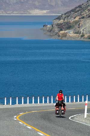
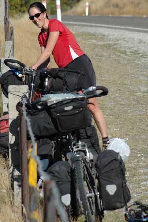
30th March 2006 - Wanaka to Makarora - 66 km The day started easy but this was without counting on NZ's ever changing climate. Today, within the 1 km that separates lake Hawea from lake Wanaka, a strong North wind materialised (ie a headwind). The first lake was extremely still and provided mirror like reflections of the the surrounding mountains while lake Wanaka had a 1 metre swell suitable for surfing. The response of the owner of the campsite in Makarora to our weather observations was one of distinct lack of surprise. Apparently "The Neck", as the small section of road between the lakes is called is renowned for this weather pattern and cyclists are constantly appearing at his campsite, sweaty, disheveled and complaining - we were no exception.
|
The mirror like reflections of the calm and windless lake Hawea on the way from Wanaka to Haast Pass |
|||
Lake Hawea and the climb over "The Neck" the calm easy cycling turned into a head down slog into the solid Northerly wind
|
The ever-present fences sometimes make a picnic spot awkward to find. Designated picnic spots also tend to be designated Sandfly feeding grounds
|
|||
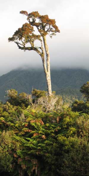
The bright sunshine finished after we crossed the Haast pass, but the forest turned to thick Beech and in this case tall podocarps
|
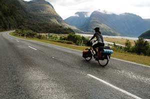
31st March and 1st of April 2006 - Makarora to Fox Glacier - 208 km What a drastic change from the dry landscape of Otago, its blue lakes and bleak mountains. As soon as we entered Mt Aspiring National Park, a thick mountain beech forest was all around us. We climbed over Haast past (the lowest pass in the Southern Alps) and from there it was all downhill to Haast township. What made the day particularly pleasant was the myriad of waterfalls on every mountain side and the amazing transparency of the rivers and streams. But every coin has a flip side: we were back into sandfly country. Lingering around to take in the views or have a sandwich in peace has become impossible. The little pests have been designed to keep cyclists on the move. The section between Haast and Fox Glacier is equally amazing. Despite following the West Coast, very little is to be seen of the Tasman sea. But the impenetrable bush is mesmerising. There is little to be seen on the way and there are only a few settlements and a few scabby fields with cows, which look very out of place amongst the surrounding jungle-like bush. |
|||
One of the many interesting little clefts in the huge rock walls carved out by the 6 metres of rain that falls every year
|
The magnificent descent from Haast Pass through huge river valleys with the glaciated, heavily forested landscape everywhere
|
|||
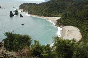
The West Coast road only touches the sea in a couple of places - but they really are dramatic untouched landscapes
|
A West Coast beach near Knights point - idyllic - especially if you are a 2 mm long flying insect and like to suck the blood from innocent mammals
|
|||
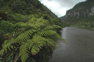
2nd April to 3rd April 2006 - Fox Glacier to Franz Joseph Glacier - 36 km We left Fox Glacier under pouring rain. We escaped the 5.7 m annual rainfall in Fjordland. We must have run out of luck. The ride between the two glaciers consisted of 200m up then down, and again, and again. Pfff, tiring especially under the rain but we had a chance to see the rainforest how it should really look: very wet and rainy! We decided to spend a day or two at Franz Joseph. It was a good idea: the weather forecast posted on the information centre had a heavy rainfall warning for the day. 150mm of rain to be expected between the 2nd and the 3rd of April (for those of you yet to convert to metric that's a full 6 inches!). Our Ortlieb bags are giving signs of old age and have leaked. Our room (yes, finally a room with a bed!) looked like a refugee camp with all our gear dripping dry in every free corner. (right) Ferns, manuka, podocarps and beech trees provide the wild, untamed natural forest cover for much of the West Coast. Not easy for wild camping without a machete |
 |
|||
 |
(right) At the terminal face of the Fox Glacier. The intention was to do some Glacier walking but the rain was atrocious. So we set off for the Franz Josef Glacier, where the rain worsened and we visited the terminal face of another glacier - and still no glacier walking! |
|||
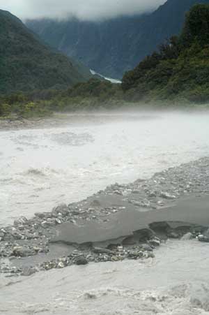
(above) Up until recent years cyclists were ridiculed for their bizarre clothing choices, skin tight lycra and gaudy colours etc. These days most cyclists are at the cutting edge of fashion! (right) The vast quantities of rain managed to swell the rivers to demonstrate that the frequent warning signs aren't joking. The rising mist above the river was caused from the difference in temperature of the icy glacial river water and the moist, temperature air straight off the Tasman sea |
|
|||
4th and 5th April 2006 - FJ Glacier to Hotikita - 146 km Most of the road up to Hotikita goes through more lush bush, but contrarily to the Russian forests, which can get a bit weary after days of riding through them, we cannot get enough of NZ bush. There are bundles of climbing trees, orchids and flowers growing on top of each others on both sides of the road. We were relatively lucky with the weather, but the mountains to the East were constantly wrapped in thick clouds - a constant reminder that the next downpour could strike us at any moment. The disappointment of the West Coast route is the lack of coast. The road travels a good distance inland and only touches the sea briefly on a couple of occasions.
|
Sunset over the Tasman Sea from a jade and quartz covered beach of Hokitika
|
|||
Care to be taken on another combined road/rail bridge - otherwise a serious crash involving unexplained loss of feet will result
|
The coastal strip of the West Coast road gets a surprising amount of sun in the afternoons - the mountains to the East are frequently shrouded in clouds
|
|||
Despite the torrential rains of the previous days, we were refused drinking water twice. On one occasion, there was not enough water to allow campers to stay at a campsite (and it was getting dark, we were cycling and it was 25k to the next town), on the other one, the water needed boiling because of the strong rains. So cyclists short of water, beware or open your mouth when it rains!
|
||||
|
There are many little sleepy towns. In Harihari, the first successful solo plane crossing from Australia landed head first in the mud. In Ross, there is a working Gold mine. But this was not of as much interest to us as the delicious cafe that bakes home-made cakes and meat pies, hum..., more pies please! In many of the old pictures of the West Coast, men proudly exhibit a long thick bushy beard. We cannot but smile when we found out that it still seems to be fashionable with the older folks around there (it takes some time to grow beards of such luxuriant quality and length). It used to be Gold and now it's jade that brings tourists, rather than miners, to Hotikita. We successfully crossed China without buying anything resembling jade (we were subjected to a lot of heckling and chasing), but would we finally break in Hotikita? We even camped in a place called "the ultimate jade experience" where you have to spend 6 to 10 hours polishing your own jade pendant. Well, tempting offer, but no thanks... But you can pick up Jade straight of the beach in it's rough natural pebble form
|
|||
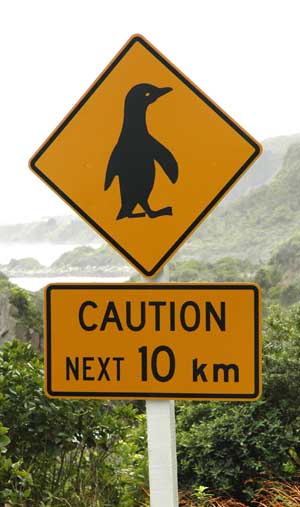
6th and 7th April 2006 - Hotikita to Westport - 157 km - Finally following the real West Coast! It is only North of Greymouth that the West Coast appeared in all its splendour. It is what everybody kept talking about and what we have been waiting to see for the last 400 km! The view unveiled itself at the road meandered around huge limestone cliffs. There are rock pinnacles, stacks, caves and arches being pounded by the the huge waves, beautiful beaches, waterfalls, the strange pancakes rocks of Punakaiki (named by a chap who surely called a dog a dog), shags everywhere and the occasional penguin wandering on the road to keep the interest going.
|
Stacks of Pancake rocks |
|
||
|
|
|||
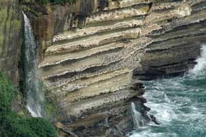
Waterfalls straight into the Tasman sea and hundreds of shags (cormorants) enjoying the views from the limestone ledges
KEEP AWAY FOR 4 MONTHS - One of the many areas that have been aerially bombarded with poison
|
We were also back into the sub-tropical zone, which means that the forest featured a few new species, such as the Nikau palm tree. The rain caught up with us again, bringing its full meaning to the term "rain forest". We had an interesting chat with a retired possum-hunter (see our fauna and flora section to see this little beastie). He explained to us how unpopular the Department of Conservation (DOC) has become since dumping poison on the bush to kill the possum (hunting possum is no longer economically viable). Wild deer have been found to have significant levels of 1080 poison in their meat and cannot be sold anymore; the locals dogs are dying, leaving the locals angry and worrying about where all the dumped poison is going exactly, the watercourses? Invertebrates? Who knows? It is a hugely contentious issue in the New Zealand countryside. Well would you like a helicopter to blanket bomb the hillsides around your house with a concoction that kills all mammals? Especially if there seems to be insufficient scientific studies as to the long lasting effects on other wildlife. Man has changed much of the look of the New Zealand countryside, flora and fauna beyond recognition in the last 150 years and that process isn't going to stop soon.
|
|||
|
From Haast to Westport the rain forest changes from Temperate to sub-tropical. Terry admiring the Nikau Palms in the Sub Tropical coastal area between Greymouth and Westport |
|||
In New Zealand the coal just hangs around in open seams in the cuttings at the side of the road. In China people would have tunneled miles into the hill by hand and swept the road clean of any remaining dust
|
The start of the day at Westport, a strong westerly gale, huge surf and scary thunderstorms- but the wind was behind us
|
|||
|
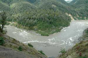
The aim was to reach the DOC camping ground at Lyell, an old gold mining ghost town. A late start, coffee, internet flight bookings, rain, and mechanical problems meant that the dark and rain swept over us as we approached Inangahua. There we found a strangely quiet backpackers accommodation - we let ourselves in, stoked up the wood burning stove and settled in to our new home - a complete house all to ourselves. The road from Westport to Inangahua follows the Buller river with great views of the native bush and the turbulent river, swollen by all the recent rain. We cycled this stretch on a Saturday and it was very quiet - just the odd campervan and no logging trucks. We awoke the next day and found the weather had worsened again - so we decided to spend the day at the backpackers for a full day's rest and keeping dry. There was only a small shop badly stocked and a village hall with an interesting exhibition on the 1968 earthquake that struck the village. Having given to both of these the full half hour required, Terry delved into his sacred statistics spreadsheet and found out that we had completed 16,000 kms and 1000 hours in the saddle the day before. What an achievement! Time to get the moisturiser out and work on those arse callouses.
|
||||
10th/12th April 2006 - Inangahua to Motueka - 190 km We eventually left our new home in Inangahua and followed the Buller river for another 80km passing through the relative metropolis of Murchison. The traffic was busier as it was Monday but the steep bush-clad mountains and frequent waterfalls helped take our minds off it. The Upper Buller gorge did not have quite as good views as the lower section because the river was normally hidden in the bush a hundred metres below the road. We had decided to stay at a "bikepackers" accommodation in Glenhope and found it to be on the only stretch of dual carriageway on the West Coast and with a 17% climb up the gravel driveway to the house. Isa fell off her bike and ended up pushing the last 30 metres! |
The Buller river in the Upper Buller Gorge. A view down to the river from a section of the road that disappeared in the 1968 earthquake |
|||
The lovely Glenhope to Tadmor road |
From Glenhope we avoided the busy, straight, steep and boring SH6 and took a small backroad towards Tadmor before rejoining the main road into Motueka. It was a lovely gravel road for 16 kms, twisting and turning with great views of the nearby National park and the river below without a single other vehicle. We rejoined the Motueka highway and travelled North through mainly forestry plantations until we arrived in the climatic bubble of the Tasman Bay region. Suddenly apple trees appeared, then kiwi fruits and lemon trees and vineyards. It was a dramatic and sudden change. The special climate is caused by the relatively sheltered position making this small area the sunniest region of New Zealand. We decided to take advantage of the prevailing weather patterns and hire a sea kayak for 3 days and explore the Abel Tasman National Park.
|
|||
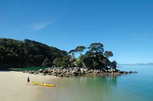
13-15th April - Kayaking Abel Tasman NP We hired the kayaks from Kaiteriteri and after a brief instruction session and enormous fuss trying to fit all our equipment into three tiny compartments we were off onto the open Tasman Sea. The Tasman National Park has idyllic beaches, many only reachable from the sea and provides a wonderful introduction to sea kayaking. At high tide the rivers are turned into tidal lagoons which penetrate deep into the native bush. The wildlife is not afraid of the kayaks and so close encounters with birdlife and seals is easy and exhilarating. |
Our first beach stop on our 3 day kayak trip
|
|||
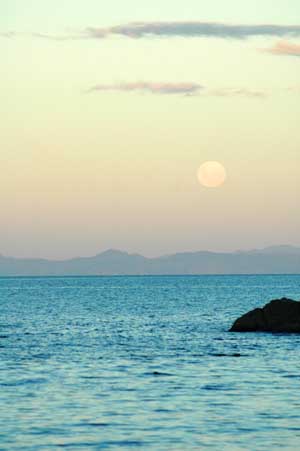
Moonrise over the Marlborough Sounds viewed from the Abel Tasman
|
The kayaking bit was pretty easy - taking photos was a little more difficult |
|||
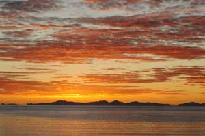
Sunrise replacing the moonrise the next morning over Marlborough Sounds again |
Seal pups showing great curiosity and amazing underwater dexterity in Shag Harbour
|
|||
The beaches in the Abel Tasman National Park are breathtakingly beautiful - Isa had to pinch herself to check she wasn't dreaming
|
Terry undertaking some hydraulic improvements / modifications to the small river on Mosquito beach - the modifications were generally considered to be a success.
|
|||
One of many places of worship which would appear to be declining in popularity
|
16th April - Motueka to Nelson - 68 Km This was a special day - it was exactly a year ago that a man shouted "twats" as us as we left Worcester and a year ago that we waved our friends goodbye after a nice pub meal in Upton Upon Severn. Nonetheless, our legs had to take us to Nelson over a gentle hill, set away from the main road. It was a lovely ride amongst quiet villages, old wooden farm houses, apple and, oddly, olive trees. The ride from Richmond onwards was not so pleasant as we were back on the main road, but we made it on time to Nelson for a celebration lunch with a few Monteiths beers.
|
|||
17th of April - Visiting rainy Nelson It was Easter monday and the rain that has not fallen for the last five months decided that this was the day to come down to earth. Nelson was therefore very quiet and we felt that we missed the best of it. Still, it was nice to rest the legs. The Easter weekend also meant that almost everything was closed, supermarkets, museums and shops. We therefore had a tour around by bicycle to the local beach and returned to our campsite suitably drenched.
|
||||
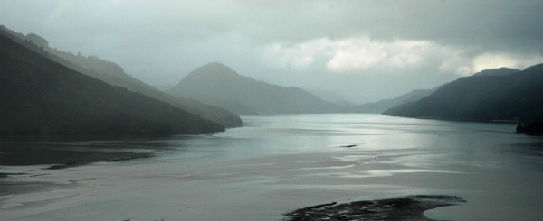
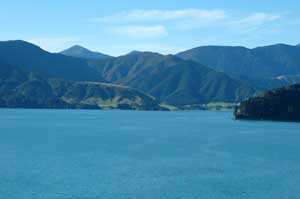
The first views of the Marlborough Sounds - looking North up Pelorus Sound
|
||||
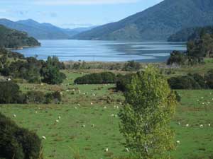
18th April - Nelson to Moetapu bay - 99 km The road out of Nelson followed the coast initially but the enjoyment was spoilt by the fast traffic, including many articulated lorries and logging trucks. There was no shoulder on long stretches of road and the bends were very tight as the road wiggled up the mountains through forestry plantations. Havelock marked the start of the queen Charlotte drive, which stretched along the Marlborough sounds. This road is a beautiful scenic drive. We only saw part of it that night, as we stopped at the start of Pelorus Sounds, yet it was already stunning. With the clouds in between the peaks and the sea all around us, the scenery reminded us of Scotland. We struggled to find the DOC campsite we intended to stay at. We were even told by 2 different locals that there was no DOC camping in the area. There were only two options: hold faith in our map or go back over the steep hill just behind us. We finally found our spot. But it was dark by then and we had carry our bikes down 50m of steep, muddy steps before reaching the bay. The operation was miraculously completed without any muddy falls, but after 20 minutes struggling and cursing.
|
|
|||
Arrival in Picton - one lap of the South Island completed in 3,393 kms
|
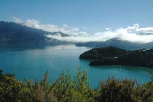
19th to 20th April - Moetapu bay to Picton - 83 km We had two beautiful and sunny days in the Marlborough sounds. Stunning, fabulous, breathtaking, amazing, awesome, oh, and very, very hilly. We were torn with the idea of riding sections of the Queen Charlotte track (the longest mountain bike single track in NZ) but we met some muddy hikers and one very muddy biker, who confessed, after a bit of prompting, to having pushed his bike for half the way. At Picton, we then realised that the track is described in terms of "dry, drying out, wet", so the mud seems to be a recurring problem here and we bottled out of our off-road plans. Instead we rode on the beautiful Queen Charlotte drive all the way to Picton. The road followed many bluffs and bays and the views over the Sounds were commanding. On arriving in Picton, we crossed the mini-roundabout that we passed three months ago. One lap of the South Island completed!
|
|||
|
21st April - Picton to Wellington by ferry and 6 km of sweaty climb Our ferry was cancelled (an all too often occurrence, according to the New Zealanders) so we visited Picton, which is a pretty, but rather small place to the traveller with three hours to spare. The crossing of the Cook straight for Wellington made up for our wait. Contrarily to our arrival in the South Island, we had good weather and could leisurely enjoy crossing the Marlborough sounds by boat. A small pod of dolphins joined us and played in the surf created by the ferry. It was a fine way to leave the South Island. The sweaty climb was to reach our friends Paddy and Julia's house in Karori, which is synonymous to "tough long climb" to any cyclist familiar with Wellington's undulating topography. |
Terry on the ferry back to the North Island and a chance to repair the broken bikes |
||
|
22nd to 26th of April - Wellington, definitely the most Southerly capital city in the world and maybe our favourite too We had a fabulous time with Paddy, Julia, Katie, Maggie and their generous crowd of friends who all took in turn to feed us nice stuff, from roast meals to yummy Pavlova cake. Paddy was on a mission to make us change our mind about NZ red wines, which we deemed as "not so good" in our drink report, so we were generously wined too. A few walks with Maggie (the dog) cleared our foggy heads and made us discover a few of the beautiful outskirts of Wellington. Makara beach is particularly pretty and a good spot to fish the shimmery paua shells. Wellington is really a nice city to visit, where people still take time to be friendly and say "thank you driver" when they step out of the bus. So it is with many regrets, but very sleepy heads that we left Wellington by the 7 o'clock plane to Brisbane, Australia.
|
|||
|
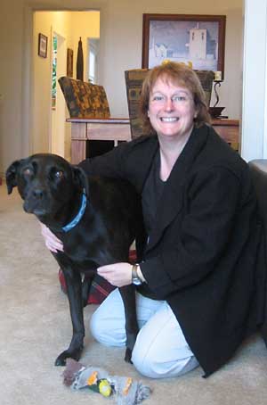
Our generous hosts for 6 days in Karori (above) Paddy, Isa, Katy and Terry on top of Johnson's Hill, Karori, Wellington. Katy did well to stay on her feet for the duration of the photograph! (left) Julia, Maggie dog and trashed duck toy |
|||